Research
Research Interests
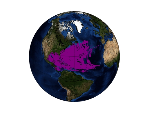
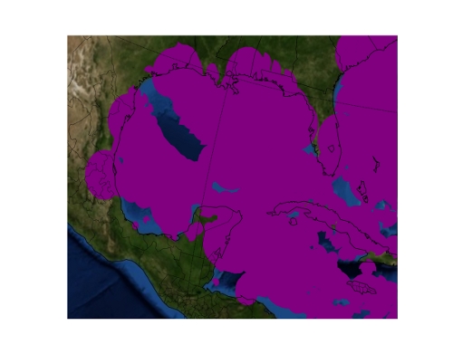
- Spatio-temporal Databases: Databases that can represent objects that change shape and position over time are of great importance to many application areas. For example, hurricanes change position, shape, and size over their lifetime. I am interested in modeling and implementing spatio-temporal databases for the support of data analysis, especially in the application contexts of hurricanes and wild fires. The following images depict some basic analysis of hurricane data distributed by the National Hurricane Center. The first image shows recorded areas of hurricane force winds for all Atlantic hurricanes since 1988. The second image shows a closer view of the Gulf Coast. It is interesting to note that a few areas on the Gulf Coast have avoided hurricane force winds, according to this data. One of the largest of the areas is from Port Lavaca, TX to Kingsville, TX. Thus, even basic analysis of this data reveals interesting observations. The goal of this research effort is to enable much more sophisticated analysis tools and underlying database infrastructure that can aid in reducing the number of injuries and property damage caused by hurricanes, wild fires, and other phenomena.
- Spatial Modeling: How is space fundamentally represented in both mathematical terms, and in terms of computer representation. I am interested in integrating thematic and spatial data into comprehensive models that can then be utilized to create efficient algorithms and storage structures for spatial data. Furthermore, topics such as topological relationships, spatial partitions, three dimensionals spatial objects, moving objects, and spatial information theory fall under this area.
- Spatial Databases: This area deals with problems that arise when implementing spatial models and storing spatial data in a database context. I am interested in new storage and query processing techniques for managing spatial data in more efficient ways.
- Spatial Networks: The modeling, storage, and manipulation of spatial networks presents new challenges to traditional spatial modeling techniques. However, spatial networks are of vital importance. For example, road networks, power grids, and gas pipes are form networks. By representing these networks in computer systems, analysis, simulation, and emergency response can be performed quickly by computers to provide information to workers in the field.
- Geographical Information Systems: GIS is a widely used tool that is used to manipulate and analyze spatial data. I am interseted in findong new ways to implement GIS systems that take advantage of new spatial modeling techniques. Ultimately, this will form the foudnation of the next generation of GISs.
- Emerging Database Systems: As new application areas, such as biological, genomic, spatial, temporal, and network databases, are developed new challenges in storing complex data arise. I am interested in finding general techniques to integrate complex data items into existing database systems.
Thesis Topics
The following list contains some specific research topics that are suitable for a thesis. Contact me if you are interested in pursuing one of these topics, or if you have another a topic in mind that you wish to discuss.
- Spatial Indexing: Find new ways to index spatial data in databases to improve query performance and spatial operation performance.
- Maps in Spatial Systems: This topic looks at integrating maps as first class citizens in spatial databases and GISs. We have found that GIS systems that take advantage of this are more efficient, more simple to implement, and easier to use.
- Parallelism in Spatial Operations: This topic examines methods of achieving parallelism in spatial algorithms. Many spatial algorithms do not lend themselves to parallelism, but discovering methods to achieve parallelism will significantly increase the efficiency of spatial systems.
- Spatially Embedded Network Modelling: Spatially embedded networks are used to represent road, river, and utility networks (electrical, water pipes, etc.). This topic involves developing methods to represent spatial networks, both mathematically and in computer systems. Also, operations, predicates, and algorithms over spatial networks must be studied.
- Moving Objects Databases: This topic looks at how objects that move in space and time can be represented and operated on in database systems.
- Complex Object Management in Databases: The data in emerging database applications, such as spatial, biological, and genomic databases, is characterized as having complex structure and variable length. New mechanisms are required to manage this data effectively and efficiently in database systems.
Funding
- SIUE STEP: Cyberinfrastructure to Support Active learning in Undergraduate STEM Courses. For year 2015.
- NSF supported CyberGIS Center for Advanced Digital and Spatial Studies Fellow: CyberGIS Education Modules for Integration with Existing Undergraduate Curricula. For year 2014.
- SIUE EUE: Developing Hybrid Course Materials. For year 2014.
- HPC Educators LittleFe Equipment Grant. 2013 International Conference for High Performance Computing, Networking, Storage, and Analysis (SC13). $3,000 (1 LittleFe unit).
- SIUE STEP: MoGeo: A Scalable Moving Geometry Database”. $15,780 for year 2012.
- II-New: Shared High Performance Data Center. NSF Computing Research Infrastructure (NSF CRI). $50,000 for year 2011.
- Paradigms in Information Retrieval. NSF Research Experiences for Undergraduates (NSF REU). $359,840 for years 2011–2013.
- Computing Spatiotemporal Regions from Sensor Data. Texas State University Research Enhancement Program (REP). $8,000 for year 2009.
- MAPSTORE: Using Maps to Index Spatial Data. Texas State University Research Enhancement Program (REP). $8,000 for year 2008.
- University of Florida Stephen C. O’Connell Presidential Fellowship. 2005-2008.
Code
PySpatioTemporalGeom: An open source, python library implementing algorithms and operations over regions and moving regions. The easiest way to use the package is to use pip install pyspatiotemporalgeom. See the paper Pyspatiotemporalgeom: A Python Library for Spatiotemporal Types and Operations listed below for a description of aspects of the library. If you use this package to support a publication, please consider citing that paper. For details, see the package link below.
- Documentation: http://www.cs.siue.edu/~marmcke/docs/pyspatiotemporalgeom/
- Source Code: https://bitbucket.org/marmcke/pyspatiotemporalgeom/
- Package: https://pypi.python.org/pypi/pyspatiotemporalgeom
Parallel Plane Sweep: Two implementations of the plane sweep algorithm, a quadratic implementation using vectors and a linearithmic implementation using an AVL tree. Both versions can be run on a single thread, or multi-threaded on a shared memory platform. See the paper Multi-core parallelism for plane sweep algorithms as a foundation for GIS operations [http://rdcu.be/mFBN] listed below for details. If you use this code to support a publication, please consider citing that paper. Source code is open source.
- Documentation: http://www.cs.siue.edu/~marmcke/docs/parallelplanesweep/
- Source Code: https://bitbucket.org/marmcke/parallelplanesweep
Parallel Grid Overlay: Compute the overlay of two regions using a uniform grid decomposition. Two implementations are incuded: one that uses hash tables to compute the grid decomposition, and one that uses vectors to compute the grid decomposition. Parallel versions of both implementations are also included. Parallel versions use OpenMP for shared memory parallelization. Code is open source.
- Documentation: http://www.cs.siue.edu/~marmcke/docs/gridoverlay
- Source Code: https://bitbucket.org/marmcke/code_spatialDecompositionOverlay
Selected Publications
- M. McKenney, N. Nyalakonda, J. McEvers, M. Shipton, “Pyspatiotemporalgeom: A Python Library for Spatiotemporal Types and Operations.” ACM SIGSPATIAL. 2016. [
PDF] - M. McKenney, M. Schneider. “Map Framework: A Formal Model of Maps as a Fundamental Data Type in Information Systems.” Springer. 2016. ISBN: 978-3-319-46764-1 (Print) 978-3-319-46766-5 (Online) [http://link.springer.com/book/10.1007/978-3-319-46766-5]
- M. McKenney, R. Frye, M. Dellamano, K. Anderson, & J. Harris (2016). Multi-core parallelism for plane sweep algorithms as a foundation for GIS operations. GeoInformatica, 1-24. [http://rdcu.be/mFBN]
- M. McKenney, R. Shelby, and S. Bagga. “Implementing set operations over moving regions using the component moving region model.” GeoInformatica, 2016. [http://rdcu.be/mFBU] [
PDF] - M. McKenney, R. Frye, Z. Benchly, and L. Maughan, “Operations to support temporal coverage aggregates over moving regions.” GeoInformatica, 2016. [http://rdcu.be/mFBY] [
PDF] - M. McKenney, R. Shelby, and S. Bagga, “Component Moving Region Operations: Implementing Set Operations on Region Streams.” IWGS at 23rd ACM SIGSPATIAL International Symposium on Advances in Geographic Information Systems, November 2015, Bellevue, WA, USA
- M. Mckennney and R. Frye. 2015.” Generating Moving Regions from Snapshots of Complex Regions.” ACM Trans. Spatial Algorithms Syst. 1, 1, Article 4 (July 2015), 30 pages. DOI=http://dx.doi.org/10.1145/2774220.[
PDF] - M. McKenney, R. Frye, Z. Benchly, and L. Maughan, “Temporal Coverage Aggregates Over Moving Region Streams.” IWGS at 22nd ACM SIGSPATIAL International Symposium on Advances in Geographic Information Systems, November 2014, Dallas, TX, USA [
PDF] - L. Maughan, M. McKenney, & Z. Benchley, “A Model of Aggregate Operations for Data Analytics over Spatiotemporal Objects.” In Advances in Conceptual Modeling (pp. 234-240). Springer International Publishing. 2014. [
PDF] - M. Mckenney, S. Viswanadham, E. Littman, “The CMR Model of Moving Regions.” IWGS at 22nd ACM SIGSPATIAL International Symposium on Advances in Geographic Information Systems, November 2014, Dallas, TX, USA [
PDF] - M. McKenney, B. Olsen, “Algorithms for Fundamental Spatial Aggregate Operations Over Regions,” BIGSPATIAL at 21st ACM SIGSPATIAL International Symposium on Advances in Geographic Information Systems, November 2013, Orlando, FL, USA. [
PDF] - D. Tamir, C. R. King, M. McKenney, “Improving the Performance of Constructive Multi-Start Search using Record-Keeping.” International Conference on Industrial, Engineering and Other Applications of Applied Intelligent Systems, June 2012, Dalian, China.
- M. McKenney, G. De Luna, S. Hill, L. Lowell, “Geospatial Computation on the GPU.” 19th ACM SIGSPATIAL International Symposium on Advances in Geographic Information Systems, November 2011, Chicago, IL, USA.
- M. McKenney, “Algorithms for Spatial Data Integration.” Recent Trends in Information Reuse and Integration, 2011, Springer.
- C. R._King, M. McKenney, D. Tamir, “Improving the Performance of Multi-start Search on the Traveling Salesman Problem.” International Conference on Industrial, Engineering and Other Applications of Applied Intelligent Systems, June 2011, Syracuse, NY, USA. [
PDF] - C. Nova, A. Qasem, H. Rashid, M. McKenney, “Dynamic Programming Solutions for the Integral Knapsack Problem on Multicore Architectures.” INFORMS Computing Society Conference, January 2011, Monterey, CA, USA.
- M. McKenney, J. Webb, “Extracting Moving Regions from Spatial Data.” 18th ACM SIGSPATIAL International Symposium on Advances in Geographic Information Systems, November 2010, San Jose, CA, USA. [
PDF] - M. McKenney, “Geometric and Thematic Integration of Spatial Data into Maps.” IEEE International Conference on Information Reuse and Integration, August 2010, Las Vegas, USA. [
PDF] - M. McKenney, T. McGuire, “A Parallel Plane Sweep Algorithm for Multi-Core Systems.” 17th ACM SIGSPATIAL International Symposium on Advances in Geographic Information Systems, November 2009, Seattle, USA. [
PDF] - M. McKenney, “Region Extraction and Verification for Spatial and Spatio-Temporal Databases.” Scientific and Statistical Database Management, June 2009, New Orleans, USA. [
PDF] - M. McKenney, R. Praing, and M. Schneider, “Constructing Topological Relationships between Regions with Holes.” 13th Intl. Symposium on Spatial Data Handling, June 2008, Montpellier, France. [
PDF] - M. McKenney and M. Schneider, “Topological Relationships Between Map Geometries.” DASFAA, March 2008, New Delhi, India. (best paper candidate) [
PDF] - M. McKenney and M. Schneider, “PLR Partitions: A Conceptual Model of Maps.” ER (Workshops) - First International Workshop on Semantic and Conceptual Issues in Geographic Information Systems (SeCoGIS), November 2007, Auckland, New Zealand. [
PDF] - M. McKenney, A. Pauly, R. Praing, and M. Schneider, “Ensuring the Semantic Correctness of Complex Regions.” ER (Workshops) - First International Workshop on Semantic and Conceptual Issues in Geographic Information Systems (SeCoGIS), November 2007, Auckland, New Zealand. [
PDF] - M. McKenney, M. Schneider, “Spatial Partition Graphs: A Graph Theoretic Model of Maps.” 10th International Symposium on Spatial and Temporal Databases, July 2007, Boston, USA. [
PDF] - M. McKenney, A. Pauly, R. Praing, M. Schneider, “Local Topological Relationships for Complex Regions.” 10th International Symposium on Spatial and Temporal Databases, July 2007, Boston, USA. [
PDF] - M. McKenney, A. Pauly, R. Praing, M. Schneider, “Preserving Local Topological Relationships.” Proceedings ACMGIS‘06 (14th ACM International Symposium on Advances in Geographic Information Systems) [
PDF] - M. McKenney, A. Pauly, R. Praing, M. Schneider, “Structured Large Objects in Databases.” Technical Report, Department of Computer and Information Science and Engineering, University of Florida, 2006. [
PDF] - M. McKenney and M. Schneider,”Advanced Operations for Maps in Spatial Databases.” 12th Intl. Symposium on Spatial Data Handling, July 2006, Vienna, Austria. [
PDF] - M. McKenney, A. Pauly, R. Praing, M. Schneider, “Dimension-Refined Topological Predicates.” Proceedings ACMGIS‘05 (13th ACM International Symposium on Advances in Geographic Information Systems), December 2005, Bremen, Germany, ACM press. [
PDF]